
Aintree is a left-handed racecourse in England. It is a jumps course.
Course facts
Mildmay course
| Direction | Left-handed |
|---|---|
| Character | Sharp and level |
| Course length | 1.32 miles (about 10½ furlongs) |
| Home straight | 825 yards (about 4 furlongs) |
| Run-in from the last | 190 yards |
| Lowest point above sea level | 57ft |
| Highest point above sea level | 86ft |
| Winning post above sea level | 85ft |
| Notes | The chase course is on the inside. |
Grand National course
| Direction | Left-handed |
|---|---|
| Character | Galloping and level |
| Course length | 2.19 miles (about 17½ furlongs) |
| Home straight | 860 yards (about 4 furlongs) |
| Run-in from the last | 485 yards (about 2 furlongs) |
| Lowest point above sea level | 48ft |
| Highest point above sea level | 86ft |
| Winning post above sea level | 85ft |
| Notes | The Chair and the water jump are omitted on the final circuit. |
Course map
Jumps course
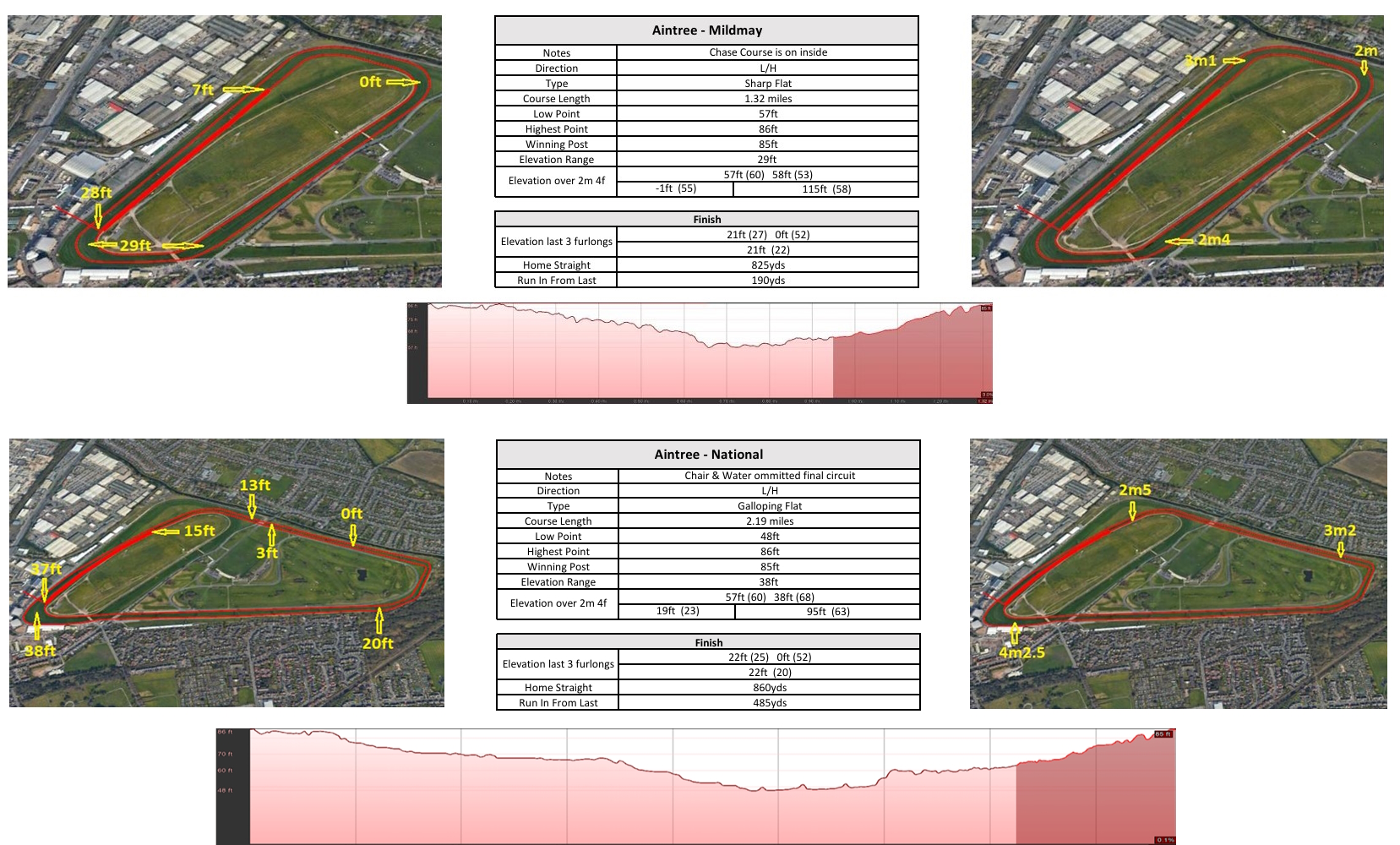
Course facts are taken from Proform's course maps. Heights are in feet above sea level.
Aintree in figures
Racing here next
No races are declared here yet.
The jumps courses
| Course | Circuit | Direction | Track | Gradient | Home straight | Climb in the straight | Finish |
|---|---|---|---|---|---|---|---|
| Mildmay course | 1.33 miles | Left-handed | Sharp | Slightly Down & Uphill | 795 yds | +23 ft | Uphill |
| Grand National course | 2.19 miles | Left-handed | Galloping | Down & Uphill | 845 yds | +25 ft | Uphill |
How the races are run
How the winners raced over the last 5 years: the share of the winners that led, raced prominently or were held up, with the share of the runners in brackets, shaded the same way.
| Trip or type | Races | Led | Prominent | Held up |
|---|---|---|---|---|
| Chases, Mildmay course | 97 | 21% (14%) | 49% (41%) | 30% (45%) |
| Hurdles, Mildmay course | 128 | 15% (11%) | 46% (36%) | 39% (53%) |
| Bumpers, Mildmay course | 27 | 11% (8%) | 41% (35%) | 48% (57%) |
| Chases, Grand National course | 23 | 4% (4%) | 65% (30%) | 30% (66%) |
Course and trip measurements from the Proform course maps; results from Proform RaceMetrics.